If you take the tram from central Lisbon and straight west (a modern tram, unfortunately, not one of the city’s famous antique ones), you will reach the neighbourhood of Belém in less than an hour. This is a more tranquil, open-spaced part of town than the city centre, with its narrow, busy streets. It is home to a number of museums, historic buildings and monuments. It is also where you find the bakery Pastéis de Belém, where visitors line up around the block to buy the world-famous egg-based pastry elsewhere known as pastel de nata, well worth the trip alone.
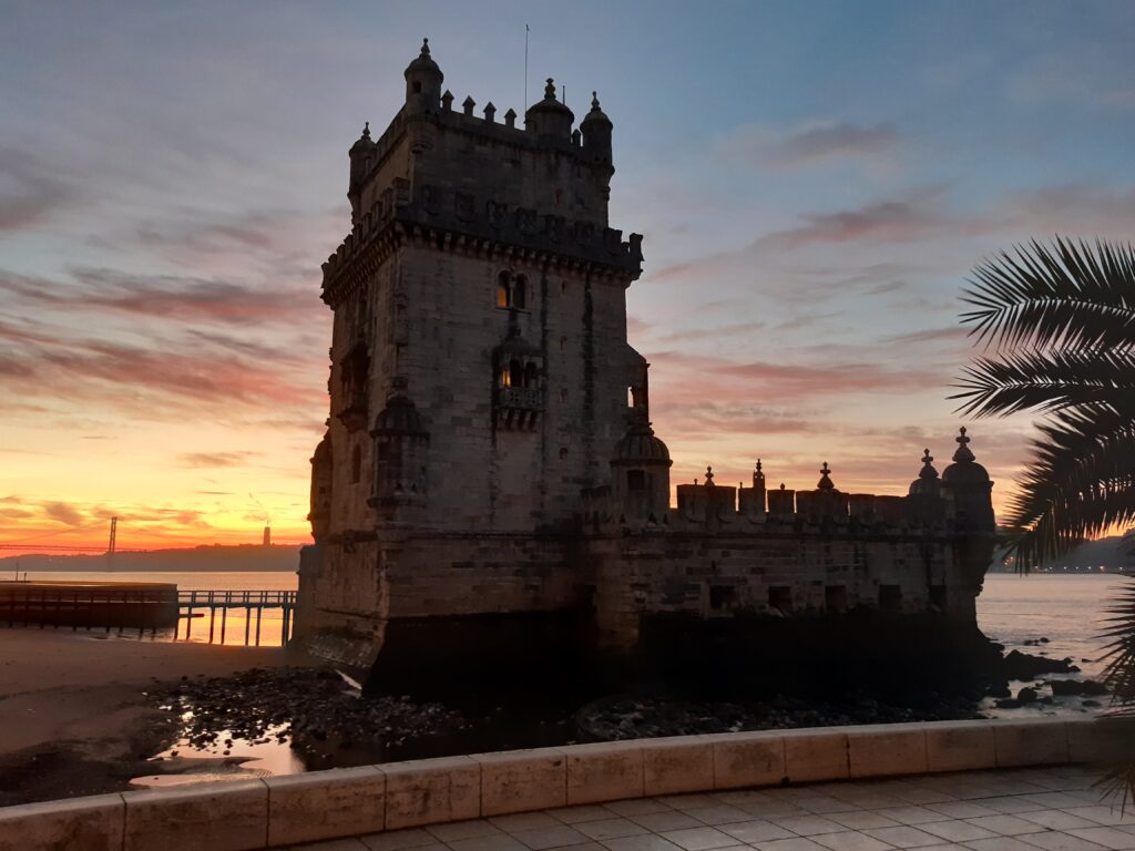
At the very edge of town, just where the Tagus River runs into the ocean, stands the Torre de Belém, a fortified tower once used as a point of departure for ships sailing into the Atlantic. Simple in its basic construction, it is delightfully intricate in its ornamentation. The so-called Manueline style, named after king Manuel I (1495-1521), incorporated elements from numerous lands and cultures, as well as from the maritime craft itself. Most notable is a stone representation of a rhinoceros – the same animal king Manuel gifted to Pope Leo X, which would later serve as inspiration for Albrecht Dürer’s famous woodcut.
The tower is often used as a symbol of Portugal maritime history, and it is easy to imagine the great explorers embarking here before venturing into the unknown. Easy, but somewhat inaccurate. The tower was finished in 1519, when most of the great discoveries had already been made, and only shortly before the first circumnavigation of the globe. The preceding century, however, had been one of the most consequential periods in human history, thanks in no small part to this small, unassuming European nation.
How did Portugal achieve such implausible prominence, to become the foremost maritime nation on earth? The country undoubtedly started out with significant advantages. For one thing, it had finished its Reconquista – the Christian reconquest of the Iberian Peninsula from its Muslim overlords – as early as 1249. Unlike Spain, which did not fully reclaim her territories until 1492, Portugal now was a unified, homogenous nation with clearly defined borders.
From the Muslims, however, they had acquired skills in navigation and shipbuilding. By combining Arab technology with their own North-Atlantic trading vessels, they developed ships that were better adapted to open ocean navigation than Mediterranean, shore-hugging crafts.[1] Lacking Spain’s Mediterranean coastline, it was therefore only natural that Portugal should focus her efforts outwards.
Credit for this push is normally given to one man in particular: the royal prince known to posterity as Henry the Navigator. In spite of his nickname (never used until the nineteenth century), Henry was not much of a seafarer himself. He is only known to have made one major voyage overseas, though a significant one. In 1415, Portugal first expanded beyond its European borders by conquering the North-African city of Ceuta. It was a costly and mostly pointless affair, but for Prince Henry, who took part in the expedition, it was eye-opening. The Muslim sultanate they had just defeated was enormously rich in commodities like gold and slaves, traded across the Sahara. If the Portuguese could find a coastal route to their source, they could skip the middleman and acquire these goods directly. In the long run, they might even reach India, with its invaluable spices.
But exploration was not carried out for mercenary reasons alone. Hand in hand with the hunger for gold went a commitment to spread the true faith worldwide. An old legend told of the Christian kingdom of Prester John beyond the Muslim lands: a powerful empire that could help liberate Europe from the pincer hold of Islam. The legend was not entirely unfounded; the nation of Abyssinia – today’s Ethiopia – was one of the oldest Christian kingdoms in the world, But as the Portuguese adventurer Pêro da Covilhã discovered when he made his way there overland in 1493, this was no great empire, and could offer little help to those of a crusading disposition. Only Europe could encircle Islam.
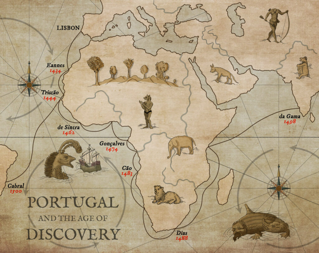
What followed the capture of Ceuta was a series of expedition under royal sponsorship, though surely only some of these were noted down by the chroniclers. In 1434, Gil Eanes rounded Cape Bojador in Western Sahara (all references to countries and territories in the following use contemporary names). Europeans had now navigated farther down the coast of North-Africa than Moorish sailors ever had, and the path south lay open to them. By 1446, Nuno Tristão had reached as far as the Gambia. Around 1460, Pedro da Sintra sighted the mountains he named Serra Leoa – the mountains of the lioness – after the roars of thunder that emanated from them.
But 1460 was also the year in which Henry the Navigator died, and royal interest in exploration waned in his absence. Instead of expeditions sponsored directly by the royal family, the rights of exploration were now leased out to a man by the name of Fernão Gomes. Under Gomes’s leadership, the entire coast of the Gulf of Guinea was traversed – the source of the riches that Prince Henry had dreamt of half a century earlier.
In 1474, however, a setback was encountered when Lopes Gonçalves reached the eponymous Cape Lopez in Gabon. First of all, it now became clear that the coast of Africa stretched far southwards beyond this point. This meant that finding a seaway to India would be much harder than hoped for, if at all possible. Secondly, the North Star disappeared below the horizon once ships crossed the Equator. The sailor’s best friend, the point they had used since time immemorial to stake out true north, was now gone, and other methods had to be found. Lastly, those who sailed down the coast of southern Africa encountered strong headwinds, making progress slower.
These were the challenges Portuguese sailors faced when John II ascended to the throne in 1481. Unlike his predecessor, Alfonso V, whose focus had been on crusading in Morocco, John took an active interest in maritime exploration. Towards that purpose he sponsored the expeditions of three of Portugal’s most celebrated seafarers in turn: Cão, Dias and da Gama.
Diogo Cão was the first to carry with him so-called padrãos: stone columns crowned with a cross meant to mark the farthest extent of Portuguese exploration. Some of these monuments have been retrieved and can be seen at the Lisbon Geographic Society, though his last one, raised in Namibia, is lost.
Cão had explored an enormous stretch of the African coastline, and set the stage for his successor, Bartolomeu Dias. By rounding the Cape of Good Hope, Dias reached the southernmost point of Africa, where the passage into the Indian Ocean lay open. This was significant not least because it contradicted the teachings of Ptolemy, the greatest classical authority on geography. According to Ptolemy’s highly influential Geography, southern Africa was connected by a land bridge with east Asia, making the Indian Ocean an enclosed sea. By the fifteenth century this convention was being challenged, and Dias’s discovery vindicated the modern view. At this point, however, the crew started getting nervous, and persuaded their captain to turn around. This was no mutiny, but simply an expression of the democratic spirit that was necessary for long-range expeditions like this to succeed.[2]
With the seaway to India now wide open, it is somewhat curious that it should take another decade for the next major expedition to be equipped. To some extent, this can be explained by a succession dispute at court, and the death of John II in 1495. Partly, the problem remained of finding a way to traverse the difficult south-easterly winds that had made previous voyages so arduous. An extraneous event, however, also played a part.
In March 1493, a Spanish ship had to seek refuge in the harbour of Lisbon. The crew of the ship, the Niña, claimed that they and the captain of their small fleet, Christopher Columbus, returned from having reached the Indies by travelling due west. The Portuguese must have taken this assertion with a pinch of salt (rightly so, as it turned out), but due caution dictated that the claims be met with diplomatic action. Subsequent negotiations, presided over by the papacy, led to the Treaty of Tordesillas of 1494. Through this, the world was divided into two spheres of interest, with a line running down the length of the Atlantic Ocean. To the west of the line, the right of exploration and conquest would belong to Spain, to the east, to Portugal. The path towards India was now theirs.
When time finally came for the next major expedition, one great problem had been solved. The north-westerly winds that Cão and Dias had struggled against are part of a system called the Atlantic Gyre. Winds here move in a clockwise direction on the northern hemisphere, and counterclockwise in the south (see map). To round Africa, it is therefore preferable to head out into open water once past the Equator, and only then follow the natural currents east to round the Cape. This was a method the Portuguese called volta do mar, meaning “turn of the sea”, that they had already practiced for a long time in the north Atlantic. It is not unlikely that, during the “lost decade”, minor voyages we do not know about today had discovered that it worked in the south Atlantic as well.
The man chosen to lead this expedition, Vasco da Gama, therefore knew how to navigate his way into the Indian Ocean. Such an operation must nevertheless have been not a little intimidating, requiring, as it did, an unprecedented period on the open sea. Da Gama left the coast behind around the area of Sierra Leone. By the time his sailors again laid eyes on Africa, they had been out of sight of land for thirteen weeks, far longer than any European ship before them.
Making his way up the eastern coast of Africa, da Gama entered an area of hostile, Muslim dominance. An exception was found in the harbour of Malindi, in Kenya, where he was able to recruit the services of an expert local navigator, who led the Portuguese safely across the Indian Ocean. On 20 May 1498, the ships sailed into Kozhikode in south-western India, closing a long chapter in the history of human exploration. When asked what he was looking for, da Gama is said to have answered “Christians and spices”.
But Portuguese exploration did not end here. The year 1500 was somewhat of an annus mirabilis for the nation. This was the year when Diogo Dias – Bartolomeu’s brother – first sighted the island of Madagascar. Sailing in the opposite direction, Gaspar Corte-Real reached Greenland and, the next year, also Newfoundland and Labrador. But the most consequential discovery was made by Pedro Álvares Cabral, the captain chosen to follow in da Gama’s wake as commander-in-chief of the Second Portuguese India Armada.
Following da Gama’s advice, Cabral headed west around Cape Verde. We know this because da Gama’s instructions to Cabral survive.[3] But Cabral made a much wider turn than da Gama had, so wide, in fact, that he eventually hit the eastern tip of Brazil. Why, with all the expertise available to him, would he have veered so far astray? There is of course the possibility that a mistake was made, or that winds or currents forced the fleet off course. But there is also another possibility, and this brings us back to the Treaty of Tordesillas. This treaty was preceded by the 1493 papal bull Inter Caetera, which had drawn the line much farther east. Through clever negotiations, John II managed to move the line west, into what the Spaniards assumed was empty ocean.[4]
But this failed to take into account the rather bizarre geography of the Americas. If asked to draw North and South America, most people would probably place one squarely on top of the other. But a look at the map reveals that this is not the case at all; the southern continent juts significantly farther out into the Atlantic than its northern cousin. In fact, fully ninety percent of South America lies east of New York City.
The Portuguese must have suspected that there was a landmass in the southwest Atlantic, and by 1500, this had indeed been confirmed.[5] Portugal thereby had the rights to what would later become Brazil, but deliberately sending expeditions of exploration into the Western Hemisphere could still be perceived as an act of aggression by the Spanish crown. Cabral’s manoeuvre therefore ensured a level of plausible deniability, while opening up eastern South America for colonisation.
One last chapter remains in the book of exploration, though for the Portuguese, this one leaves a bitter taste in the mouth. Fernão de Magalhães, an experienced navigator, was snubbed by the court of Manuel I and offered his services to the Spanish crown instead. Here, under the name of Fernando de Magallanes, he embarked on an expedition to reach the Indies by sailing south of the Americas. He himself was killed along the way, but after a journey of three years, one ship from his fleet made it back to Spain in 1522. With this, the first circumnavigation of the globe was completed. There was no more world to conquer; filling in the blanks was now the only part remaining of the Age of Discovery.
What do we mean, though, when we speak of the “Age of Discovery”? On the face of it, the term seems a little absurd, first of all: is it really possible to “discover” land that is already inhabited? Secondly: had not humanity been exploring new territories since its inception? This includes incredible feats of navigation, such as those of the Polynesians and the Vikings. The Arab traveller Ibn Battuta visited great parts of Africa and Asia long before any European, and documented his travels in a highly influential book. In the early fifteenth century, Admiral Zheng He carried out several voyages across the Indian Ocean for the Chinese Emperor, in ships that dwarfed the European caravels. Is it simply arrogant Eurocentrism to give precedence to our discoveries over those of others? Is any land terra incognita until European feet have trod on it?
There is certainly an element of cultural chauvinism to the way in which this period has been described in past historiography. But at the same time, there is an undeniably unique element to the exploration done by European nations in the fifteenth and sixteenth centuries. While previous exploration had mostly been gradual and local, these were of a whole different nature. In the course of a century, the entire world was connected through navigable shipping routes. And these routes did not disappear with the people who first sailed them; they became permanent and only grew in importance over time. The world we live in today would – for better or worse – be impossible to imagine without this sudden burst of activity.
And Europe, in turn, was also changed in the process. Beyond the obvious surge of trade and commerce, the new discoveries affected almost every field of human understanding. After having been confined to their tiny little corner of the globe for a millennium, knowing what lay beyond only through vague rumours and myths, the entire world now opened up to them, with its endless variety of cultures, landscapes and lifeforms. Accounts of the wide variety of human societies forced philosophers such as Hobbes, Locke and Rousseau to reflect on what was humanity’s true state of nature. Naturalists like Humboldt and Darwin travelled the world to gather information and develop new theories on geography and biology.
A particularly contentious field of debate concerned the rights of the conquered vis-à-vis the conquerors. One of the main objectives of exploration had after all been the proliferation of the Christian faith. It therefore followed that the conquering states had a spiritual obligation to convert the natives to Christianity, but also that the crown had a duty of care towards their new subjects. The Spanish, who exercised direct rule over a far greater number of conquered people than Portugal, were especially conscious of their obligations as protectors of the Catholic faith. Previous to the European Age of Discovery, no conquering power had ever given much thought to issues concerning these matters.
Few embodied this spiritual struggle better than the Dominican friar Bartolomé de Las Casas. Based on his own missionary work in the New World, Las Casas developed a deepfelt concern for the wellbeing of the native peoples, whom he had seen suffering and dying at an appalling rate. He argued that American Indians should enjoy the same rights as metropolitan Spaniards, and that they should be allowed to organise themselves in self-governing communities. This precluded any form of servitude, which was at this point widespread. Las Casas’s arguments were countered by those of the philosopher and theologian Juan Ginés de Sepúlveda, who, based on Aristoteles, argued that the natives by nature were inferior to Europeans, and were therefore destined to be ruled over.
After a formal debate between the two in 1550, it was Las Casas’s view that won through, and the Spanish crown ended up restraining the behaviour of colonial settlers, in their exploitation of the native population. The ultimate consequence of this, however, was that the resulting shortage of labour was filled by importing slaves from Africa. The transatlantic slave trade was at this early phase dominated by Portugal, with their dominion over African territories.
Las Casas lived to see these consequences of his advocacy, and bitterly regretted the part he had played. There is altogether a pervasive sense of the cognitive dissonance of empire in this quite genuine concern for the conquered peoples contrasted with the brutal realities on the ground. These concerns then went out the window completely, once the transatlantic slave trade commenced. Some may have comforted themselves that the slaves in question were convicted felons, but such an illusion became untenable with the sheer scale the business soon took on. The answer was a reversion to the Aristotelian “natural slave” philosophy.
Portugal, meanwhile, found herself in the strange situation of being one of the greatest empires on earth, yet still the junior partner on its own peninsula. Spain is five to six times the size of Portugal, and the population differential was probably even greater than this in the sixteenth century. To maintain friendly relations, the Portuguese royal house had entered into marriage alliances with Spain, but this carried its own risk. When the Portuguese royal line failed, in 1580, the country was forced into union with Spain, and Philip II of Spain also became Philip I of Portugal.
This union was dissolved, and Portuguese independence restored, in 1640. By that time, however, irreparable damage had already been done. Philip, in his indefatigable struggle against Protestant heresy, imposed embargoes on the Netherlands and England, by which Portugal was also bound. These countries, up until then happy to import their spices and other colonial goods through Lisbon, now entered into the eastern trade themselves. In 1600, the English East India Company was founded, and in 1602 the Dutch East India Company. The Dutch in particular soon proved much more efficient than the Portuguese at navigation, administration, trade and warfare, and eventually ousted Portugal from most of her possessions in the far east.[6]
All was not lost, however, since the jewel of the crown, Brazil, still remained on Portuguese hands. This possession proved immensely valuable when, towards the end of the seventeenth century, large deposits of gold and diamonds were discovered here. This new Age of Gold brought great prosperity to the nation, but also this came at a cost. The crown was now independently wealthy, and no longer relied on the community of the realm for grants of taxation. After 1698, there were no more meetings of the Cortes – the Portuguese parliament – and the kings and queens ruled as absolute monarchs.
The resulting decline of a vibrant political society was reflected in the nation’s intellectual life. The state practiced strict censorship over publication, and Portugal regressed as the age of scientific discovery progressed across Europe. Economically, there was no need for modernisation and innovation, and the country remained stuck in an agrarian state with minimal industrialisation. In international trade, Portugal grew dependent on England, where Portuguese wines were particularly popular.[7] This period of European history marks a junction, where states that managed to expand the sphere of civil participation in the affairs of state – such as England and the Netherlands – prospered, while those that did not – like France, Spain and Portugal – fell behind. That pluralism and openness that had allowed Europe to encircle the world, once it failed, the conquering nations failed as well.
Portugal’s greatest modern poet, Fernando Pessoa, writes in his masterwork, The Book of Disquiet: “In my dream I experienced freedom, as if the South Seas had offered me marvellous islands to be discovered.”[8] But by the early twentieth century, when Pessoa wrote, there were no more islands to be discovered. All he could do was dream. This most solipsistic of poets turned inwards, the way his country could only turn inwards.
And at the mouth of the Tagus lies an ancient tower, staring blankly out into nothing.
Sagres
On 1 November 1755, the people of Lisbon were crowding the city’s places of worship for All Saint’s Day, when an earthquake struck. As the buildings collapsed over congregants, a tsunami struck those who had sought refuge along the riverbank. As much as a fifth of the city’s population may have died that day. The ruins of Carmo Convent, seen here, have been preserved as a memorial to the tragedy. The event led many to doubt a providential universe, and seek solutions in human reason instead. As such, the earthquake served as a catalyst of the Enlightenment. Among these enlightened men we may count the architect Manuel de Maia, who led the work to construct the world’s first earthquake-resistant city. The result still stands today, in the form of the neighbourhood known as Baixa, or “Downtown”.
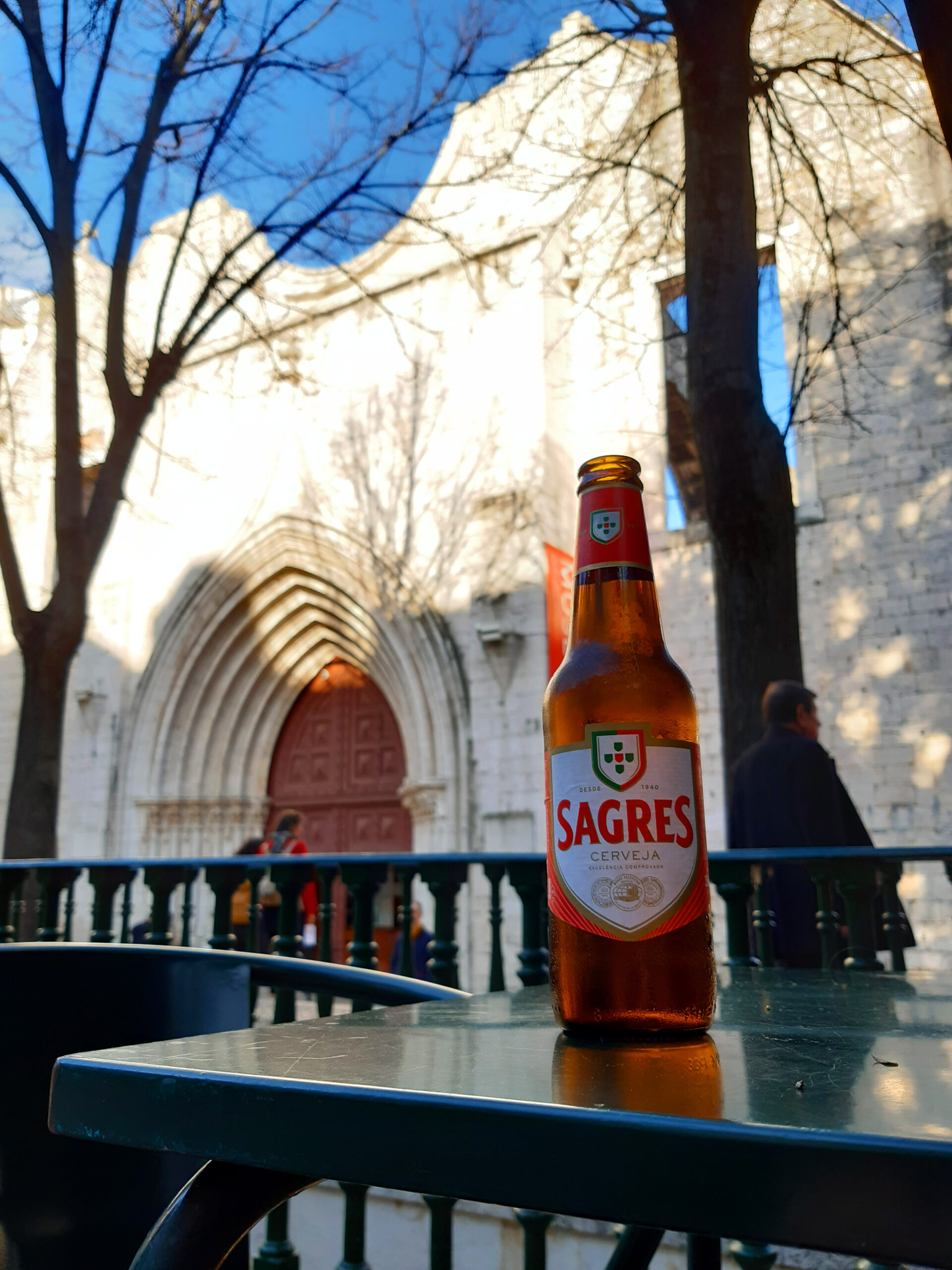
To return to Henry the Navigator, tradition has it he founded a school of navigation at Sagres, on the south-western tip of Portugal. There is no evidence that any such school existed, but the town has nevertheless given its name to a popular brand of beer. Brewing in Portugal is essentially a duopoly: the largest being Super Bock, brewed in Porto, followed by Sagres, made in Lisbon. It has a sweet, sparkly feel to it, but still carries a little bite.
[1] David Arnold, The Age of Discovery, 1400 – 1600 (Routledge, 2002), 31–32.
[2] J. H. Parry, The Age of Reconnaissance (University of California Press, 1981), 137‑38.
[3] S. E. Morison, ‘Sailing Instructions of Vasco da Gama to Pedro Álvares Cabral. 1500’, The Mariner’s Mirror 24, no. 4 (1938), 402–8.
[4] Parry, The Age of Reconnaissance, 193–94.
[5] M. D. D. Newitt, A History of Portuguese Overseas Expansion, 1400-1668 (New York : Routledge, 2005), 65.
[6] Anthony R. Disney, A History of Portugal and the Portuguese Empire 1: Portugal (Cambridge Univ. Press, 2009), 210–12.
[7] Disney, A History of Portugal and the Portuguese Empire. 1, 262–63.
[8] Fernando Pessoa et al., The Book of Disquiet, Penguin Classics (Penguin, 2002), 17.